
Sweetwater Country (central Wyoming)
Sweetwater agate, moss agate, and jasper across the Granite Mountains and the Sweetwater River drainage. BLM ground with long, lonely roads.
82 mapped spots across 19 counties. Wyoming is a good state for agate, jade, petrified wood, and fossil fish. The Sweetwater agate fields, Wiggins Fork petrified wood area, Wyoming jade country, and Kemmerer quarries are the main anchors.
Representative spot and material photos from locations in this state, shown where verified public image records are available.
Map showing 82 rockhounding spots in Wyoming
Counts reflect how many spots in this list mention each mineral.
Notable areas: Sweetwater agate, Wyoming jade, Wiggins Fork petrified wood, and Tin Cup quartz are common Wyoming targets.
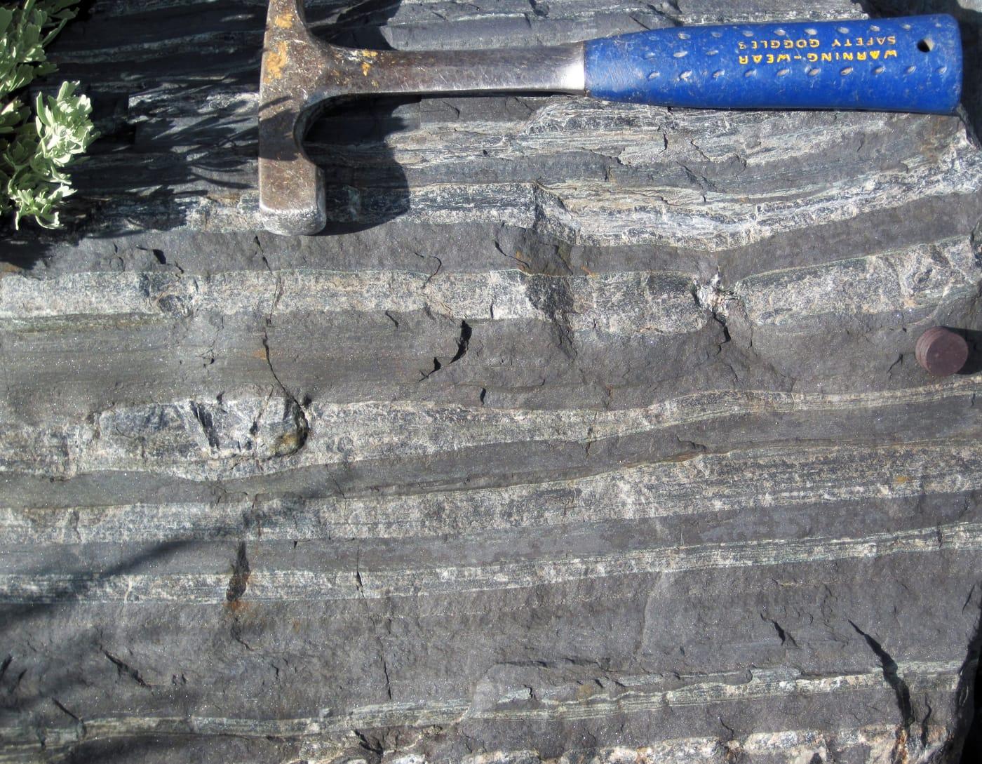
Wyoming is half BLM by area. Its collecting hot spots reflect Eocene to Miocene lake-and-volcanic geology: the Sweetwater River basin's agate-and-jasper gravels (Granite Mountains source), the Wiggins Fork and Absaroka Mountains' opalized and silicified wood, the Granite Mountains' nephrite jade, and the Green River Formation's fossil fish near Kemmerer (commercial quarries plus public quarry days).
Sweetwater agate, moss agate, and jasper across the Granite Mountains and the Sweetwater River drainage. BLM ground with long, lonely roads.
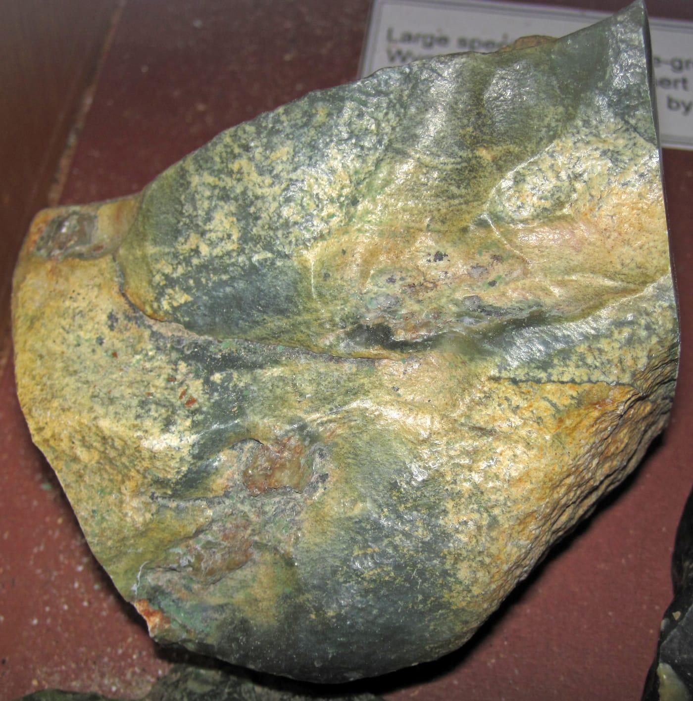
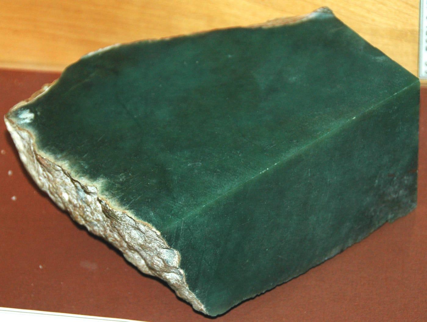
Nephrite jade as float and in-place. The hunt is patient — most surface material was picked over in the boom years, but the area still gives up jade after washouts.
Permineralized wood in Eocene tuffs of the Absaroka volcanic province. Remote — high country with grizzly habitat. Travel in groups.
Fossil fish at commercial quarries (American Fossil, Ulrich's, Warfield, Tynsky's) on public quarry days. Knightia is the typical catch.
June–September. Wyoming's high desert is cold and wind-scoured the rest of the year. Kemmerer quarries run May through October.
Wind shell, bear spray (for the Absaroka country), full-size spare and high-clearance vehicle, water for the day, paper map. For Kemmerer fossil quarries: small chisels and a flat-blade screwdriver — the quarries provide most tools.
Jade was designated Wyoming's state gem in 1967. The Sweetwater agate fields had their first big rush in the 1930s and 1940s, when collectors fanned across the Granite Mountains by horseback. Wiggins Fork petrified wood has been worked since the 1950s.
Day-trip range. Each section lists the closest mapped rockhounding spots within about 150 miles of the city — most are inside a 2 to 3 hour drive.
6 closest spots to Cheyenne, WY.
6 closest spots to Casper, WY.
Geology rarely respects state borders. These states share mapped rockhounding country with Wyoming — useful when Wyoming is the start, not the whole trip. Each card links to the closest county across the line.
County pages are linked once we have at least 3 mapped spots for a focused guide with coordinates, mineral notes, and nearby spots.
Hand-picked standouts from the Wyoming list, chosen for unusual mineralogy, documented public access, or both. Each card links to coordinates, access notes, and what to look for.
 Top pick
Fremont County
Sweetwater agate is Wyoming's signature agate, and the Sweetwater River drainage is the classic field area tied to the Granite Mountains source terrain. WSGS publications describe Sweetwater material among the state's better-known agates, while BLM rules make casual surface collecting possible on open public parcels when claims and ownership are checked first.
Agate
 Top pick
Fremont County
Atlantic City sits in the South Pass country, where Wyoming's gold-mining history overlaps with the central Wyoming jade and agate belt. The mix of quartz, muscovite, tourmaline, jasper, chalcedony, and nephrite makes it a broader hard-rock and float locality than the single-material Sweetwater agate stops nearby.
Agate, Chalcedony, Gold, Nephrite Jade
 Top pick
Fremont County
Warm Springs is a strong Granite Mountains-area pick because it combines Wyoming jade targets with agate, jasper, chalcedony, quartz, and silicified wood in one public-land collecting corridor. WSGS identifies jade as Wyoming's best-known gemstone and also lists agate, petrified wood, and quartz crystals among the state's important collector materials.
Agate, Chalcedony, Jasper, Jade
 Top pick
Park County
Kirwin is the strongest metallic-mineral contrast to Wyoming's agate and wood localities, with USGS work documenting the district's copper, gold, lead, zinc, molybdenum, and silver mineralization. The specimen suite, including chalcopyrite, galena, sphalerite, pyrite, quartz, azurite, and malachite, makes it a focused historic mining-district stop rather than another chalcedony field.
Azurite, Barite, Chalcopyrite, Cuprite
 Top pick
Sweetwater County
Eden Valley is the Wyoming benchmark for silicified and agatized wood, with Mindat records tying petrified wood to Eden Valley and the Blue Forest area. It also has unusually clear legal framing, since BLM specifically allows limited personal-use petrified wood collecting on open public land while keeping fossil and commercial-use rules separate.
Silicified Wood
 Top pick
Sweetwater County
Wamsutter is the practical Wyoming stop for dark fossiliferous lapidary material sold as Turritella agate, more accurately tied to silicified Green River Formation gastropods. The locality stands out because the material is both fossil-rich and polishable, but BLM fossil rules still matter because vertebrate fossils and scientifically significant specimens are not casual-collecting targets.
Turritella Agate
 Top pick
Lincoln County
Kemmerer anchors the western Green River Formation belt, where public-land outcrops and gravels can yield chert, chalcedony, jasper, silicified wood, and fossiliferous lapidary stone. It is included separately from the paid fossil-fish quarries because the best free collecting value is common lapidary material on verified public parcels, not commercial quarry access.
Turritella Agate, Chalcedony, Chert, Jasper
 Top pick
Albany County
The Laramie Mountains add a southeastern public-land agate, chalcedony, and jasper stop to a Wyoming list otherwise dominated by Sweetwater and Green River Basin material. WSGS mineral references also place the range in a broader hard-rock context, which gives the locality more geologic range than an ordinary gravel-bar agate stop.
Agate, Chalcedony, Jasper
 Top pick
Carbon County
Seminoe Reservoir represents the Seminoe Mountains side of Wyoming's jade and lapidary-rock story, with WSGS noting silicified banded iron formation from the Seminoe Mountains alongside the state's better-known jade resources. It earns a top-10 place because it broadens the Wyoming set into Carbon County while staying tied to a distinctive hard, polishable material.
Jade
 Top pick
Platte County
Hartville is the southeastern Wyoming choice for Guernsey Limestone chalcedony, including moss agate, dendritic agate, stalactitic agate, and youngite noted by WSGS. Its appeal is the combination of lapidary-grade silica and mining-district geology in a part of the state outside the central Sweetwater jade and agate belt.
Agate, Moss Agate, Chalcedony
Sorted by county. Tap coordinates to open in Google Maps, or open RockHoundR for the full map view with land overlays and weather.
Open the RockHoundR app to see Wyoming on a real map with public land overlays, weather, geology, and your saved finds.
