

Owyhee & southeast high desert
Plume agate, Owyhee picture jasper, common opal, and thundereggs. Long approach drives on dirt roads — high-clearance recommended outside of dry weather.
72 mapped spots across 22 counties. Oregon has a lot of good rockhounding in a compact area: high desert, Owyhee country, Cascade foothills, and the coast. Common finds include thundereggs, agate, jasper, obsidian, opal, and petrified wood, with many public BLM areas open to recreational collecting.
Representative spot and material photos from locations in this state, shown where verified public image records are available.
Map showing 72 rockhounding spots in Oregon
Counts reflect how many spots in this list mention each mineral.
Notable areas: Glass Buttes obsidian, Lake County thundereggs, Sweet Home petrified wood, and Owyhee jasper are common Oregon targets.
Oregon's rockhounding comes from three main settings: the Cascade volcanic arc, the Basin and Range high desert in the southeast, and the Coast Range and Klamath terranes. The Owyhee Plateau has Miocene rhyolite flows, ash beds, and lake deposits that produce thundereggs, plume agate, picture jasper, and common opal. The Cascades add basalt, obsidian at places like Glass Buttes and Burns Junction, and zeolites. Central and eastern Oregon lake beds preserve petrified wood, including material near Sweet Home and the John Day basin.
Plume agate, Owyhee picture jasper, common opal, and thundereggs. Long approach drives on dirt roads — high-clearance recommended outside of dry weather.
Obsidian in many color varieties at Glass Buttes, plus Priday Ranch and Richardson's thundereggs, jasper, and agate. Several established dig sites sit in this part of the state.
Zeolites, agate, jasper float in stream gravels, and quartz crystal pockets in volcanic flow rock. Heavily roaded by USFS, snowbound in winter.
Petrified wood near Sweet Home (Holley Blue agate area), beach agates and jasper from the Pacific coast beaches. Coast collecting is by hand only and tide-dependent.
May through October is the usual window for the high desert and Owyhee. Winter can mean snow and muddy clay roads. Coast agate hunting is strongest after winter storms, roughly November through March, when fresh gravel is exposed.
Rock hammer and chisels, safety glasses, sturdy boots, gloves, sun protection, plenty of water, full-size spare tire and a jack rated for your vehicle, paper maps or offline maps, and a way to call out (cell coverage is spotty east of the Cascades). Long pants are worth it for sagebrush country.
Oregon rockhounding grew out of early-20th-century claim work in Owyhee and Lake counties. The thunderegg became the state rock in 1965, tied to the agate-filled rhyolite nodules found around Priday Ranch and nearby ground.
Day-trip range. Each section lists the closest mapped rockhounding spots within about 150 miles of the city — most are inside a 2 to 3 hour drive.
6 closest spots to Portland, OR.
6 closest spots to Bend, OR.
Geology rarely respects state borders. These states share mapped rockhounding country with Oregon — useful when Oregon is the start, not the whole trip. Each card links to the closest county across the line.
County pages are linked once we have at least 3 mapped spots for a focused guide with coordinates, mineral notes, and nearby spots.
Hand-picked standouts from the Oregon list, chosen for unusual mineralogy, documented public access, or both. Each card links to coordinates, access notes, and what to look for.
 Top pick
Morrow County
Opal Butte is noted for hyalite and several gem opal varieties, including rainbow, contra luz, hydrophane, crystal, fire, and blue opal. That range, documented in gemological literature and Mindat locality records, makes the permission-required Morrow County site one of Oregon's more distinctive opal occurrences.
Hyalite Opal
 Top pick
Malheur County
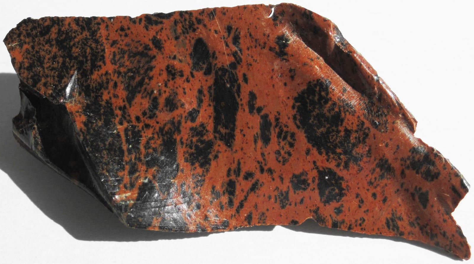
Succor Creek is a remote canyon locality where Oregon State Parks identifies a haven for rock hounds and DOGAMI lists agate, jasper, and related chalcedony-family material from the area. Its standout quality is the combination of high-desert volcanic scenery and collectible silica materials, including jasper, chalcedony, chert, and opalized wood.
Agate, Chalcedony, Chert, Jasper
 Top pick
Crook County
White Fir Spring is a public Ochoco National Forest thunderegg locality, with DOGAMI and Mindat records tying the site to agate- and jasper-filled nodules. It stands out because the Crook County material is strongly associated with jasper cores, a useful contrast to Oregon thunderegg beds dominated by clearer chalcedony.
Thundereggs
Crook County
Whistler Spring is one of central Oregon's classic free National Forest thunderegg sites, listed by DOGAMI alongside White Fir in the Madras-Prineville rockhounding belt. The site is notable for accessible rhyolite-hosted nodules in Crook County's Ochoco country, a compact example of the geology behind Oregon's state rock.
Thundereggs
 Top pick
Lake County
Glass Buttes is a rhyolite and obsidian complex with an unusually broad suite of gem-quality obsidian, including mahogany, rainbow, gold sheen, silver sheen, midnight lace, and other varieties documented by Oregon State University. The BLM-managed setting makes it one of Oregon's strongest public-land examples of volcanic glass collecting, with ordinary rockhounding rules still requiring attention to claims and local restrictions.
Obsidian
 Top pick
Lincoln County
Agate Beach is named for the agates found along the Newport and Yaquina Head shoreline, and Oregon Sea Grant notes that winter storms expose the gravel beds that supply beach agates. The site stands out because Oregon ocean-shore rules allow small noncommercial collection of agates and other nonliving natural products, making the access as important as the material.
Agate, Moonstone, Jasper, Chalcedony
 Top pick
Lincoln County
The Yachats beach area sits on Oregon's central coast, where storm-reworked gravel can expose agate, chalcedony, jasper, and related beach material. Its strength is broad legal ocean-shore access for small noncommercial collecting, paired with a shoreline that is repeatedly refreshed by Pacific winter wave action.
Agate, Chalcedony, Jasper, Moonstone
Sorted by county. Tap coordinates to open in Google Maps, or open RockHoundR for the full map view with land overlays and weather.
Open the RockHoundR app to see Oregon on a real map with public land overlays, weather, geology, and your saved finds.
