
North Idaho (Emerald Creek, Coeur d'Alene district)
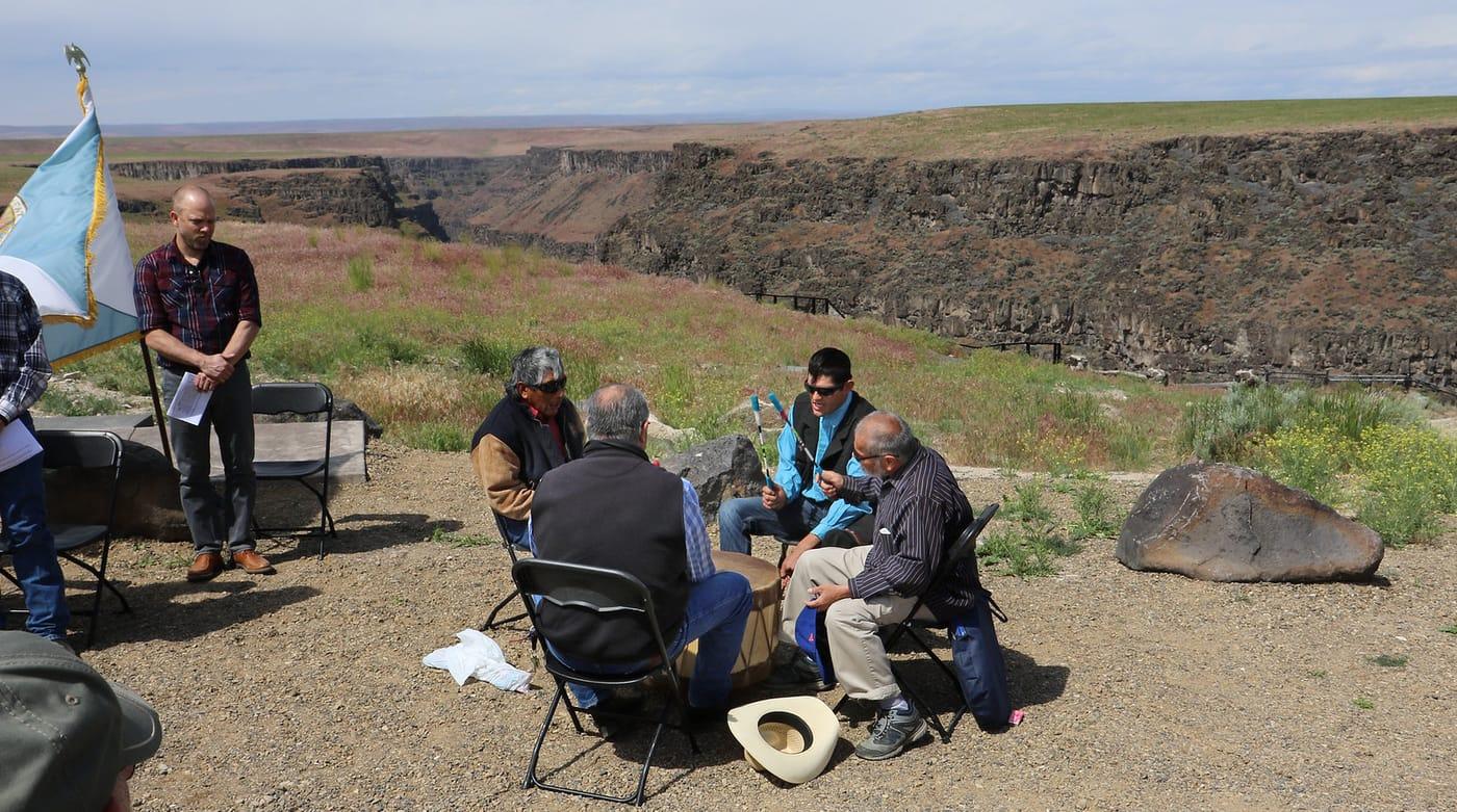
The Emerald Creek Garnet Area near Clarkia is a USFS permit dig for Idaho star garnet. The Silver Valley also has mine dump material, subject to access and claim status.
114 mapped spots across 33 counties. Idaho is known for star garnet, opal, jasper, and agate. Emerald Creek, Spencer Opal Mines, Bruneau Canyon, and the Owyhee jasper fields are the main names to know.
Representative spot and material photos from locations in this state, shown where verified public image records are available.
Map showing 114 rockhounding spots in Idaho
Counts reflect how many spots in this list mention each mineral.
Notable areas: Emerald Creek star garnet, Spencer opal, Bruneau jasper, and Graveyard Point plume agate are common Idaho targets.
Idaho's collecting splits into three big stories: the Idaho Batholith and its garnet-bearing schists in the north (Emerald Creek); the Snake River Plain volcanics and their picture jaspers (Bruneau Canyon, Graveyard Point); and the Spencer rhyolite dome in the east, which produces the only common opal in North America with a strong play of color.
The Emerald Creek Garnet Area near Clarkia is a USFS permit dig for Idaho star garnet. The Silver Valley also has mine dump material, subject to access and claim status.
Bruneau jasper, Graveyard Point plume agate, and McDermitt opal across the Idaho/Oregon line. Most ground is BLM with long approach drives.
Spencer opal at fee-dig mines — the only common opal mine in the U.S. that produces play-of-color material. Closed in winter.
Emerald Creek: open Memorial Day through Labor Day under USFS permit hours. Spencer opal: open seasonally Memorial Day through early September. South Idaho jasper country: April–October.
Emerald Creek: USFS supplies tools and a screen; bring rain gear and waterproof boots. Spencer: bring a screen, a hammer, and patience. Bruneau Canyon: 4WD high-clearance and full-size spare; the canyon is remote.
The star garnet was named Idaho's state gem in 1967. Spencer opal was discovered in the early 1960s when two deer hunters spotted opalized rhyolite on a hillside near the Montana border — the deposit has been a fee dig ever since.
Day-trip range. Each section lists the closest mapped rockhounding spots within about 150 miles of the city — most are inside a 2 to 3 hour drive.
6 closest spots to Boise, ID.
Geology rarely respects state borders. These states share mapped rockhounding country with Idaho — useful when Idaho is the start, not the whole trip. Each card links to the closest county across the line.
County pages are linked once we have at least 3 mapped spots for a focused guide with coordinates, mineral notes, and nearby spots.
Hand-picked standouts from the Idaho list, chosen for unusual mineralogy, documented public access, or both. Each card links to coordinates, access notes, and what to look for.
 Top pick
Shoshone County
Emerald Creek is Idaho's signature public star-garnet locality, with the Forest Service noting that commercial quantities of star garnet are otherwise known only from India. The managed sluice area gives collectors a rare legal way to search for dodecahedral almandine garnets while keeping digging out of the streambed.
Almandine Garnet
 Top pick
Boise County
Idaho City anchors the Boise Basin, one of Idaho's best-documented historic placer-gold regions. USGS publications identify the basin northeast of Boise as a major dredging and placer area, and nearby Grimes Pass district records add quartz and gold mineral context for modern, land-status-aware panning and prospecting.
Quartz, Garnet
 Top pick
Owyhee County
Bruneau Canyon stands out for Bruneau jasper, the orbicular and scenic jasper variety tied to the Bruneau River canyon in Owyhee County. Idaho Department of Lands lists Bruneau jasper about 50 road miles south of Bruneau, and Mindat treats the canyon deposits as a named locality, making it one of the state's most recognizable lapidary sources.
Bruneau Canyon Jasper
 Top pick
Adams County
Seven Devils is a classic Idaho skarn and copper district, where Idaho Geological Survey maps and reports emphasize limestone-garnet belts, copper deposits, and lime-silicate minerals. For collectors, that translates into a broader mineral suite than most Idaho sites: garnet, epidote, malachite, zoisite, and related contact-metamorphic material.
Epidote, Red Garnet, Pink Garnet, Malachite
 Top pick
Custer County
Challis represents the Challis Volcanics better than a single protected petrified-forest stop, with Idaho Department of Lands listing nearby red agate, banded opal, and petrified-wood localities in Custer County. Mindat records opal from the Challis area and documents agate collecting in the same volcanic province, which makes it a practical tenth pick for silica collectors.
Red Agate, Banded Opal
 Top pick
Elmore County
Dismal Swamp is a focused Elmore County locality for smoky quartz and topaz, both listed for the area by Idaho Department of Lands and Mindat. It is a more mineral-specimen-oriented choice than many Idaho agate fields, with quartz-family collecting tied to the Rocky Bar mining district and nearby granitic terrain.
Smoky Quartz, Topaz
 Top pick
Owyhee County
Succor Creek is one of the clearest public names in Owyhee agate collecting, especially for red-and-green nodules and thunderegg-style cavities. Idaho Department of Lands calls out the eastern fringe of Succor Creek specifically, and the broader Owyhee volcanic field gives the site the silica-rich source rocks behind its agate and jasper float.
Red Agate, Green Agate
 Top pick
Custer County
Mackay is the best Custer County mine-district pick for copper minerals, with Mindat documenting malachite and related species across the Alder Creek and White Knob district. Idaho Department of Lands also lists Custer County districts for azurite, malachite, and other base-metal minerals, so the site has stronger mineral documentation than a generic scenic stop.
Azurite, Chalcopyrite, Chrysocolla, Malachite
 Top pick
Blaine County
Little Wood River is the strongest Blaine County pick because the same drainage is listed for green and moss agate by Idaho Department of Lands and has Mindat specimen records from the Little Wood Reservoir area. Its agate, chalcedony, and jasper add a useful south-central Idaho counterpoint to the better-known Owyhee localities.
Agate, Chalcedony, Jasper
 Top pick
Lemhi County
Parker Mountain gives Lemhi County a documented agate and chalcedony locality outside the crowded southern Idaho fields. Idaho Department of Lands lists green and green-moss agate near Parker Mountain, while Mindat records agate and chalcedony within the Parker Mountain mining district mineral list.
Agate, Chalcedony
Sorted by county. Tap coordinates to open in Google Maps, or open RockHoundR for the full map view with land overlays and weather.
Open the RockHoundR app to see Idaho on a real map with public land overlays, weather, geology, and your saved finds.
